A 3D map of the subsurface reveals where major earthquakes may begin
Using natural electric and magnetic signals to image beneath Turkey’s Marmara Sea in 3D
What the research is about
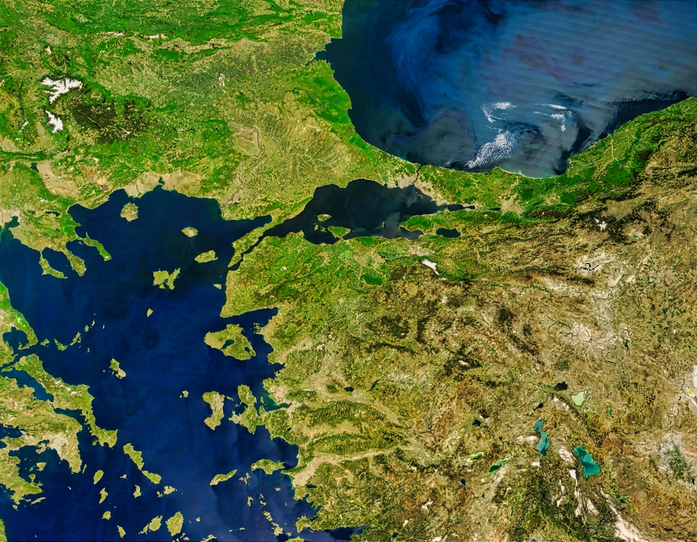
What would we find if we could look 10 kilometers beneath the seafloor? This study explores the hidden world beneath the Marmara Sea in Turkey using electricity and magnetism as clues.
This region includes the North Anatolian Fault, one of the most well-known active fault systems in the world. Since 1939, large earthquakes along this fault have occurred progressively westward. In 1999, two magnitude-7 earthquakes struck the eastern edge of the Marmara Sea. Since then, scientists have expected that the next large earthquake may occur beneath this sea.
However, until now, it has been difficult to understand the full three-dimensional structure beneath the entire Marmara Sea. Installing observation instruments on the seafloor is technically challenging, and available data have been limited. In addition, reconstructing underground structures in 3D requires extremely large computational resources. As a result, it has remained unclear how fault segments are connected and where stress is building up underground.
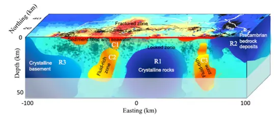
To address this, a research team led by Professor Emeritus Yasuo Ogawa of Institute of Science Tokyo (Science Tokyo) collected and integrated a wide range of data, including seafloor observations. Using advanced analytical techniques, they successfully revealed, for the first time, a three-dimensional image of the underground structure from the Earth’s crust down to the upper mantle (Fig. 1).
The method used in this study is called the magnetotelluric (MT) method. Instead of injecting artificial electricity into the ground, MT uses natural variations in electric and magnetic fields generated by solar activity and lightning. By measuring how these signals travel through the Earth, researchers can determine how easily electricity flows underground. This helps them infer the distribution of water, molten rock, and different types of rock. Previous studies have shown that areas containing fluids tend to weaken faults, making them more likely to slip and generate earthquakes.
Why this matters
The study revealed that underground conditions vary significantly from place to place. In some areas, rocks contain abundant fluids and are relatively weak. These zones are more likely to slip, and indeed, frequent small earthquakes have been observed there. In contrast, other areas consist of strong, rigid rocks that do not move easily. In these regions, stress can gradually accumulate, potentially leading to large earthquakes in the future.
In other words, the fault system beneath the Marmara Sea is not uniform. Instead, zones that move easily and zones that remain locked are distributed in a patchy pattern. Of particular interest is the area between the Central Basin (slightly west of the sea’s center) and the Çınarcık Basin in the east. This region appears to be strongly locked and may be a likely starting point for a future major earthquake.
What’s next
It is thought that some parts beneath the Marmara Sea are still storing strain energy. If this energy is suddenly released, another magnitude 7-class earthquake could occur.
The underground structure revealed in this study provides important clues about where stress is accumulating. This knowledge will help scientists better evaluate the possible size, frequency, and shaking intensity of future earthquakes. It is also expected to contribute to improved disaster preparedness strategies.
Comment from the researcher
This study was made possible through the collaboration of many researchers over more than a decade.
Three-dimensional electromagnetic imaging beneath the seafloor is still a relatively new field. In the future, we expect this approach to be applied to major earthquake-prone regions around Japan and other subduction zones worldwide. By accumulating such data, we hope to deepen our fundamental understanding of where and how earthquakes occur.
(Yasuo Ogawa, Professor Emeritus, Institute of Science Tokyo / At the time of this research: Researcher, Multidisciplinary Resilience Research Center, Institute of Integrated Research, Institute of Science Tokyo)

Dive deeper

Contact
Research Support Service Desk